Overview
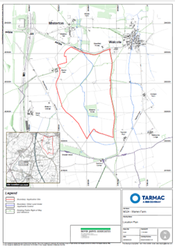
Tarmac is preparing a planning application to develop a new sand and gravel quarry located approximately 2km south-east of Lutterworth, 0.4km south of Misterton and 1km west of the village of Walcote. The proposed quarry would serve as a direct replacement for Shawell Quarry, a sand and gravel quarry located 4km to the southwest of the proposed site.
Shawell Quarry supplies construction materials to the south of the county. It is due to cease mineral extraction in around 2 years’ time. The Quarry has been operating since the 1950’s supplying essential materials for local construction projects and there are no more economically viable mineral reserves left to extract at this site.
The application for Misterton Quarry is in line with policy in the Leicestershire Minerals and Waste Local Plan, adopted in September 2019, which calls for new sites to replace exhausted sand and gravel reserves in Leicestershire during the plan period to 2031.
The proposed quarry would help meet Leicestershire County Council’s mineral supply and would support the growth within the county and the wider area. It would also assist with replenishment of the county’s landbank of sand and gravel reserves, which at the end of 2022 was equivalent to only 2 years and significantly below the 7-year minimum recommended in national planning policy.
The Site
The proposed quarry, known as Misterton Quarry, would be located to the south-east of Junction 20 of the M1 motorway and south of the A4304 (Lutterworth Road). The whole site covers approximately 112 hectares, whilst the proposed extraction area covers an area of approximately 74 hectares.
The site largely comprises arable land divided by an established hedgerow network and a central watercourse which runs north to south . Other prominent features include Misterton Gorse and woodland planting along the site’s northern perimeter. The site is also crossed by three public footpaths. We have considered all of these features as part of our environmental impact assessments and the development of our working and restoration schemes.
There are no statutory environmental designations, such as Sites of Special Scientific Interest (SSSI) and Local Nature Reserves, located on the site or in proximity, with the closest being the Misterton Marshes SSSI located approximately 1.2 km to the north.
With regard to non-statutory designations, such as Local Wildlife Sites (‘LWS’), there are none located at the site, with the closest being a potential LWS, comprising a chestnut tree adjacent to the site, along Lutterworth Road and Shawell Wood LWS located approximately 210 metres to the southwest.